I’ll never complain about the A1 again! This description of the Great North Road was written in July 1888 and published in Volume 2 of the Monthly Chronicle of North Country Lore and Legend.
~
Description of this famous highway, so far as concerns that part of it which runs from Newcastle to Morpeth, was included in a little work of mine, the “History of Gosforth,” which was published a few years ago.
The Great North Road has been from time immemorial a portion of the principal highway from the English metropolis to the capital of Scotland. What manner of road it was in the reigns of the Plantagenets and Tudors we do not know. Down to the beginning of last century it was probably not much better than a country lane — a rough kind of causeway, hard enough in summer, but full of ruts and puddles in the winter. Most of the main arteries of traffic in this country were then of that character, for travelling was the luxury — if it could be called a luxury — of the wealthy few, and good roads were not in extensive demand.
But, whatsoever may have been the condition of the road, we know that as far back as the time of the Commonwealth stage coaches were running upon it. In the year that Cromwell died a coach left London every Monday for Newcastle, and every alternate Monday it went on to Edinburgh; the journey to Newcastle occupying six and to Edinburgh seven days — thirteen in all This arrangement continued, with intermissions, for nearly a hundred years; the road undergoing no improvement, but becoming; through the increased traffic, worse and worse. In 1712 the coach running as above was advertised in this quaint manner:
All that desire to pass from Edinburgh to London, or from London to Edinburgh, or any place on that road let them repair to Mr. John Baillies’ at the Coach and Horses at the Head of the Cannongate, Edinburgh, every other Saturday, or to the Black Swan, in Holborn, every other Monday, at both of which places they may be received in a Stage Coach, which performs the whole journey in thirteen days without any stoppage (if God permit), having eighty able homes to perform the whole stage. Each passenger paying £4 10s. for the whole journey, allowing each passenger 20 lbs. weight, and all above to pay 6d. per pound. The coach sets off at six in the morning. Performed by Henry Harrison, Mich. Speight, Robt. Qarbe, Rich. Croft.
This coach ran till 1729, and then, so far as the Edinburgh portion of the journey is concerned, it was discontinued till 1763. Then it started afresh, and went from the Bull and Postboy in the Bigg Market, Newcastle, every Monday, by Morpeth and Wooler to Kelso, where passengers slept, arriving at Edinburgh the next day. On Saturdays it left Edinburgh, remaining all night at Wooler, and arrived in Newcastle on Sunday afternoons. Eight years afterwards it ran thrice a week, leaving Newcastle at five, and Edinburgh at six a.m., on Mondays, Wednesdays, and Fridays. In 1784, the Newcastle starting place was the Turk’s Head, and it ran as a diligence six days a week. A couple of years later two other conveyances ran from Newcastle to Edinburgh, staying at Berwick all night, coming and returning. One of them was a coach from the White Hart; the other a diligence from the Queen’s Head. The first mail coach from Newcastle to Edinburgh left the Cock Inn, head of the Side, November 27th, 1786. It was afterwards taken to the Queen’s Head, and finally ceased to run in 1847. It is stated that, in the opinion of the old drivers, the coldest part of the journey was the Town Moor of Newcastle, at the Blue House.
About this time the question of road improvement was pressing to the front. Marshal Wade was doing wonders in road construction away up in the Highlands, carriages with springs were becoming common, and everybody saw that the only drawback to comfortable and expeditious travelling throughout England was the deplorable condition of the public highways. Around the metropolis, and in the Southern Counties, road improvements were being effected, but nothing was done to the Great North Road until the rebellion of 1745 broke out. That abortive insurrection brought Marshal Wade to Newcastle. The great road maker experienced some difficulty in dragging his guns over the miserable highways of the Northern Counties, and the justice of his complaints and remonstrances met with a frank acknowledgment from the local authorities both in town and country. They had heard of the marshal’s doings in Scotland; they were acquainted with his extraordinary success in road construction — success so great that an enthusiastic Irish ensign said or sung;
Had you seen these roads before they were made,
You’d have held up your hands and blessed General Wade
— and they were quite prepared to take action.
The marshal was probably supported in his demand for better highways by the Duke of Cumberland, who on the 27th January, 1746 was obliged to leave his coach-and-six somewhere north of Durham and enter Newcastle on horseback. However that may be, it is certain that, as soon as the rebellion was crushed, plans of road improvement in both Northumberland and Durham were formed, and almost immediately put into execution.
In December, 1745, the grand jury, clergy, and free holders of Northumberland, represented to Parliament that the North Road, by reason of the heavy and increasing traffic, had become so deep and ruinous that travellers could not pass along it without danger. Parliament listened favourably to these representations, and a scheme was promoted for putting the road into an efficient state of repair and maintaining it in that condition. Nor were the town authorities idle. A portion of the road belonged to the Corporation of Newcastle, and an advertisement appeared in July, 1747, inviting proposals for making a carriage way from the Barras Bridge through the Town Moor to the north end of the Cow Causey, “to be eleven yards in breadth, and to be ballasted in the same manner as a turnpike road.” Parliament, the same year, passed the first Turnpike Act granted to Northumberland. By that Act authority was given to repair the road from Cow Causey to Buckton Burn, near Belford, and a body of trustees was created to carry out the improvement. The Corporation finished their part of the work in 1749, and did it very well. The trustees were not so expeditious, or else they did their portion badly, for in 1765, eighteen years after the Act was passed, one of the Edinburgh waggons “in one place opposite to Gosforth proved an overmatch to nineteen good horses.”
The Turnpike Trust thus created was renewed from time to time and ultimately expired in 1875, when Gosforth Gate and its modern associate at the borough boundary were removed, and the maintenance of the great highway fell upon the local authorities along its course. “The glory of the North Road,” writes Mr. John Hodgson Hinde, in the “Archaologia Aeliana,” “was no doubt the posting. On other roads the coaches were all as well, in some even better appointed, and speed greater; but nowhere could you drive up to an inn door with the certainty that as you drew up a relay of horses with mounted postboys would issue from the yard, and that one minute’s delay was all that was required to replace the steeds that had brought you twelve miles within the hour by a fresh team to carry you forward at the same rate.”
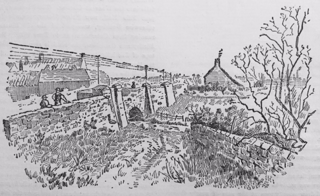
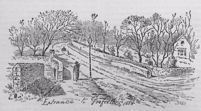
Those who travelled from Newcastle by the Great North Road when news of the battle of Waterloo sent a thrill through the nation saw before them, as they crossed the little bridge at the end of the Town Moor, an almost uninterrupted line of small meadows on the one hand, and cultivated fields on the other stretching away north to Wideopen. On the right of the bridge, in the hollow, was a small landsale coal pit; close by it Roseworth Cottage, and beyond it the church and farmstead; while on the other side were Coxlodge Hall, the Grand Stand, with the Water Company’s Mill spinning merrily round beside it; the Yellow House, or farm; Kenton Lodge, and, in the distance, the village of Kenton. The first roadside buildings in the parish were the engine shaft, the farm, and the group of cottages on the left at Causey End. A couple of hundred yards further on the coach “bumped” over Kenton and Coxlodge waggonway and past the Corving House, with the work of corf making proceeding briskly under the eye of Anderson, the master corver. More fields, then Gosforth Turnpike Gate, with Gosforth Cottage, closely adjoining it. Presently the coach rolled round the corner into Three Mile Bridge, and if the time of day was suitable the passengers caught a glimpse of stout John Maguey and his forge, and Thomas Morrow at his bench, with Pigg’s Folly between, and so, through Low and High Gosforth plantations, the coach left the parish and rattled on to Wideopen.
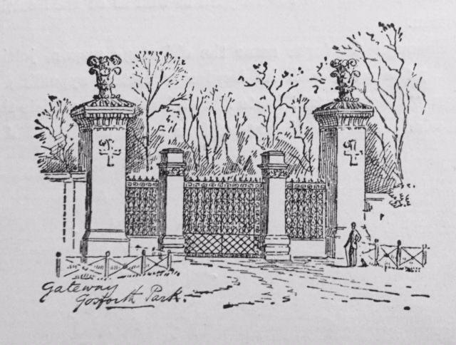
Such was the aspect of the North Road in 1815, and for ten years afterwards. But between 1825 and 1830 a change was effected. Three Mile Bridge, a narrow structure, with a recess in which pedestrians sheltered themselves from being crushed by passing vehicles, was taken down and replaced by a skew bridge — the object being to widen the thoroughfare at that point, and, by straightening the road, to avoid the awkward turn into the hamlet. This was the first skew bridge attempted in Northumberland, and the County Surveyor, Mr. Gibson Kyle, of Ponteland, was unfortunate enough to see his work give way and threaten to collapse. However, by calling in Mr. Edward Chapman, of Newcastle, and using brick for the arch instead of stone, the bridge, as we know it, was completed. About the same time, the two lodges and gateway which formed the entrance to Gosforth House about a hundred yards south of the fourth milestone were removed, and there was constructed, further north, the present “grand entrance,” with a pair of magnificent gates made of hammered iron, by Elliot, of Newcastle. As soon as the bridge was finished the entrance to Low Gosforth House was removed some distance south, and the fine wall was built that separates the two parks from the turnpike.
Presuming the theory to be correct that there has been, ever since the Saxon times, a highway from Newcastle to Edinburgh across the Town Moor, it is easy to imagine that along the North Road through Gosforth must have passed some of the kings, queens, and princes of England and Scotland; and that the industrious peasantry of that parish occasionally obtained glimpses of the English and Scottish courts — first in barbaric pomp, and later on in more civilized splendour.
William the Conqueror came through Newcastle thrice on his way to the North; Rufus was here also; King John several times; Henry III. on a visit to his daughter, who was Queen of Scots; Edwards I., II., and III. often; Henry IV. twice, and Henry VI. and his queen once, with Edward IV. In pursuit of them. Richard Crookback did not favour Gosforth with his ugly features, but his successor, Henry VII., came through the parish in 1487, on a survey of the Northern Counties, and lived in Newcastle several weeks; while in 1502 his eldest daughter, Margaret, travelled in great state along the North Road to her marriage with the unfortunate James IV. of Scotland, who eleven years later lost his life on Flodden Field.
Henry VIII., although he reigned nearly thirty-eight years, does not appear to have travelled so far north, and Edward VI. and Queens Mary and Elizabeth followed his example. But in 1603 James I. was here on his way to the English throne, and in 1617 on his way back to visit his Scottish home. Charles I. was here frequently, for himself too often; and Oliver Cromwell went backwards and forwards, receiving “great acknowledgments of love in Newcastle, and magnificent entertainments from his friend Sir Arthur Haselrigg, the owner of Fawdon. Charles I. never found time, amidst the dissipations of his court, to visit his Northern subjects, but his brother, the Duke of York, afterwards James II., passed through Gosforth in 1679, on that mournful exile to Scotland with his beautiful consort, Mary of Modena, which Miss Agnes Strickland so pathetically describes in her “Lives of the Queens of England.” We have had some celebrated persons here, such as the Emperor Nicholas of Russia, King Leopold of Belgium, the Dukes of Cumberland, Gloucester. York (2), Sussex, Brunswick, and Connaught, but there has been no reigning English monarch here since the Restoration.
Through Gosforth came, in all probability, the first postal arrangement, viz., that system of conveying news by fleet horses, stabled twenty miles apart, which Edward IV. established in 1481 to obtain news of his wars in Scotland. Down to the times of the Stuarts this “saddle horse poet” galloped backwards and forwards along the Great North Road, accompanied at intervals by special messengers bearing decrees of life and death, and ordinances of state that concerned the peace and happiness of two great kingdoms. Such a messenger was the flying horseman who, in the evening of Lady Day, 1603, some one in Gosforth may have seen, notwithstanding his “sundry shift of horses and some falls that bruised him very sore,” spurring madly away towards Widdrington, bearing to King James of Scotland the news that the sun of the Tudors had set for ever, and that he was sole ruler of the English as well as of the Scottish nation.
Through Gosforth came the old stage wagon, jolting along the road, with its burden of letters appealing in vain “Haste! post! haste!” to a lumbering vehicle that crawled onward at the rate of four miles per hour. And by and by came the stage coach, rattling over the ground as fast as the roads would allow — so fast indeed that, as we have seen in 1658, to the amazement of all the world and Gosforth, it went from London to Edinburgh in one day less than a fortnight, and left the old stage wagons hopelessly floundering behind.
Through Gosforth, seated behind the fleetest horses that the livery stables of Newcastle could produce, flew victims of the love that laughs at locksmiths, on their way to Lamberton toll-bar and other temples of Hymen on the Scottish Border. And among them, on the night of the 18th November, 1772, were John Scott, the coalfitter’s son (destined in after years to become Lord High Chancellor of England), and Bessie Surtees, the banker’s daughter, the future Countess of Eldon.
Through Gosforth came, shortly afterwards, the mail coach — long the swiftest medium of travelling in existence. Our forefathers must have looked upon this splendid equipage with wonder and delight. It was to them the great public timekeeper — rivalling the sun in punctuality, and indicating the hour when the sun was hidden by Northumbrian mist and shrouded in Tyneside fog. It was moreover the daily news-bearer from London and Newcastle, from Edinburgh and Berwick. During a time of war, and in the heat of a contested election, we can imagine the excitement at Gosforth Gate as the coach dashed past, dropping messages respecting the fortunes of the combatants to an eager crowd; and we can picture the struggle among lads from Benton in the east and Kenton in the west to be first at home with the news.
Last of all came the iron horse. And if Gosforth was not the cradle of the locomotive, it was, on the 2nd September, 1813, the scene of an interesting experiment with one. For, on that date, a steam engine constructed by a Leeds firm was placed upon the Kenton and Coxlodge wagon-way. Spectators from far and near had been summoned to see it, and amongst them was George Stephenson, the engineer of Killingworth Colliery. This locomotive was made to work by a cog wheel on toothed rails and drew seventy tons at the rate of nearly three miles an hour. Stephenson is said to have remarked that he thought he could make a better engine than that to go upon legs, and he went back to Killingworth, made travelling by steam a certainty, and removed from our great highway that huge stream of traffic which, steadily growing during a hundred and thirty-five years, formed no inconsiderable part of the daily life and interest of Gosforth parish.
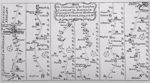
The accompanying map shows that part of the Great North Road, 70 miles long, which, beginning at Chester-in-the-Street, now Chester-le-Street, 268 miles from London, ends at Berwick-upon-Tweed, there written Barwick, 338 miles from the same city. The dotted lines show where the road was unenclosed, running, in fact, over open moors and commons. The only parts shown to have been enclosed, at the time the map was drawn, which, as far as can be ascertained, was about the year 1675, were a couple of miles after leaving Chester-le-Street, about three miles before reaching Morpeth, half a mile or so about Felton, and something like two miles after leaving Alnwick. The rest of the route was through the open country, the greater part of which seems to have been yet in a state of nature, although, of course, there were patches of cultivation here and there; the higher parts were heather-clad; there was little or no wood, except on the banks of the streams; and the remainder of the surface was a by no means rich sheep pasture. Some of the names of the places on or near the road have undergone considerable change during the intervening two centuries; thus the road at the north end of Chester-le-Street, marked as to Whittle, is that which leads to Whitley Green, a small village on the Consbeck which falls into the Wear at Chester. The Streetway leading past Pelo Hall, now Pelaw House, towards Birtley, otherwise Buckley, was part of the old Roman road running from Cataractonium to Pons Aelii. Between Birtley and Gateshead the road is seen to pass over the tops of five hills, on one of which, at a place still called the Beacon Hill, a beacon is shown, designed to be visible over all the surrounding country, to warn the inhabitants in case of invasion, and communicating by a similar light on Warden Law with a beacon on the seashore at Beacon Point, near Hawthorne. The name of the river Tyne has been misspelt by the draughtsman as “Time.” The Blyth he has set down as Bithe. Blagdon, he has converted into Beakedon, and Wansbeck into Wanspeck. We may feel pretty certain from this that he was not a man “to the manor born.” The place where the Ouseburn crosses the road, at the Three Mile Bridge, is shown on the map, but no name is given. Then follows Gosforth village, built on both sides of the road. The crossing at Seaton Burn is likewise marked, and a mile beyond it are Shotton on the right hand and Blagdon on the left side of the road. Stannington is spelt Stainington. A little to the north of Shotton, Plasshey, now Plessy, is shown. This place gave name to the ancient family of Plessis, and was possessed by John de Plessis in the reign of Edward I., at which period it was held by the service of one knight’s fee. Further on is Wanspeck Castle, properly Morpeth Castle. Hebron (written Heborn), with the adjoining townships of Tritlington and Causey, now Causey Park, are set down within a reasonable distance of their proper sites; and Espley is given as Espleby. Causet, we believe, must be a place called Cauldcote-on-the-Moor, south of Felton. Acton, Newton-on-the-Moor, and the Snipe House, are set correctly down; but Rugley, on the skirts of Aydon Forest, is misspelt as Angley. The first trees shown on the map are on both sides of the road in approaching Alnwick. The only other clumps noticed by the map-maker, are on the banks of two rivulets crossed by the road as it proceeds towards Charlton, a little to the right of which place stands Tunston Castle, probably Dunston Hall, but possibly Dunstanborough Castle. Near the 318th milestone, the road to Bamborough, misnamed Barborrow, appears to branch off, and a mile-and-a-half further on that to the village of Newstead, or Newsteed. Then comes Warrenford, misspelt Wainford. Aderdstone, spelt Atherston, the ancient seat of the Forsters, is seen a little farther on, a furlong from the road side. Mowton, now Mousen, is a mile-and-a-half further on, on the opposite side of the road, and near it, before reaching Belford, is a small place called Newlands. Just out of Belford, going northward, a chapel is marked; then comes Middleton, and after it Detchant, given as Dotchen. From Bucton, or Buckton, there is a road to the waterside at Fenham Flatts, which is marked as one-and-a-half miles off. Next comes Fenwick, spelled Famick. Kyloe is given as Hyley. Haggerstone is right spelled; and so is Broomhouse. Brig Mill seems to be Ancroft Mill. Scrimmerston is now known as Scremerston, and is the last station on the North Eastern Railway before reaching Tweedmooth and crossing the Tweed to Berwick. A fac-simile of this map, all mistakes included, was pablished in a series, comprehending the whole route from London to Berwick, in the year 1768.

Hi great reading yoour blog
LikeLiked by 1 person