Following my visit to the Roker Pier and Lighthouse I was really interested to find out some of the history of this structure. I’ve been very lucky to get some superb images to share which help to tell the story. It’s such a well-known and much loved landmark. Along with Penshaw Monument, the Wear Bridges and the Stadium of Light it is one of those structures that you just associate with Sunderland. From a distance it looks picturesque and elegant, the red and white tower precariously perched at the end of a sinew of red granite. But then, as you walk out along the North Pier you start to take in the magnitude of this feat of Victorian engineering. You notice the weather worn, rusted iron railings and the masonry worn smooth by the pounding of the sea. This is a structure that has taken a beating. Indeed, it’s very purpose was to absorb those powerful waves and protect the mouth of the wear and allow a safe haven for the ships which allowed trade and commerce to flourish. The story of the Roker Pier and Lighthouse is much more than a story of Victorian ingenuity to tame the sea. It’s the story of why such a structure was required and why so much effort and expense was justified, which is kind of the story of Sunderland itself.
First we need to take all this in context. Why was it considered necessary to invest so much to protect the mouth of the River Wear?
“Sunderland is situated near the mouth of the River Wear, in 54° 55’ of latitude, and 1° 22’ of longitude, West of Greenwich. It is contiguous to an extensive district of coals, of first rate quality, the shipment of which forms the principal trade of the place. The export of lime to Yorkshire, and the eastern part of Scotland, forms another branch of its commerce. Its foreign trade, also, is considerable, and is rapidly increasing. Ship-building is carried on to a greater extent than in any other port of the British Empire; upwards of three hundred vessels, of various burthens, having been launched there in one year. Several manufacturers of earthen-wear, iron, glass, rope and other articles are established on the banks of the river. Trade thrives under the influence of a busy population, whose unremitting exertions, it may fairly be inferred, will add still further to the prosperity of the town and neighbourhood”
Sir John Rennie, May 11, 1847.
Sunderland was indeed a thriving port in the mid nineteenth century and had been for some considerable time. In 1384 King Richard II granted permission to the inhabitants of the county of Durham, to export the produce of their mines, without the payment of duty to the Corporation of Newcastle. As Sunderland was the main port for the County of Durham this freedom allowed for the development of commerce at the mouth of the Wear. Progress was initially slow until the reigns of Elizabeth I and later James I. A real change came during the Civil War when, during the Siege of Newcastle in 1644, no coal was allowed to be exported from the Tyne and exports from Sunderland began to boom. Efforts were made to rebalance the trade after the Civil War but Sunderland was on its way to becoming one of the most important ports in the British Isles. The increasing importance of Sunderland, as a place of trade, was viewed with extreme jealousy by the Corporation of Newcastle. In 1706, when a proposal was submitted to Parliament, for the improvement of the River Wear, it was opposed by the Master and Brethren of the Trinity House in Newcastle. When a Bill for these purposes was introduced in 1716, the mayor, aldermen and common-council of Newcastle petitioned against it. Despite this an Act was obtained in 1717. It appointed Commissioners for twenty-one years, who were charged with the conservancy of the harbour and they were empowered to raise money, by a tonnage duty on ships entering the port, for the purpose of making the river navigable to Newbridge and building a pier at its mouth.
At that time the mouth of the Wear was completely unprotected and must have been a hazardous route to navigate. A pair of beacons were the only marks of guidance for vessels entering and departing from the port. The risk to shipping, the life-blood of commerce and prosperity needed to be protected.
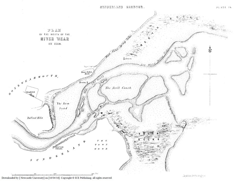
Construction of a pier on the south bank at the mouth of the river commenced in 1723 and was completed by 1726.
In July 1748 Mr. Charles Labelye, the engineer of Westminster Bridge was of the opinion that;
“the goodness both of the River and harbour was greatly impaired by many injurious circumstances.
i. Several shoals and banks of sand, which interrupted the navigation of keels down the river;
ii. By the rubbish, filth, mud, which fell into the river from the town;
iii. The increasing contraction of the river nearly opposite to the Custom House (by the tide continuing to wash the ballast heaps down into the river), which, if suffered to proceed, would be the utter ruin of the haven and also greatly endanger the wharfs and buildings adjoining;
iv. The next prejudice was the Stell, which consisted of a bed of gravel and sand, with some larger beach stones and was so shallow that a ship, drawing 9 feet or 10 feet of water, could not safely pass over it;
v. The water at the Stell dividing its self into many channels or streams;
vi. The great danger which the shipping was exposed to in the harbour, by tempestuous seas, when violent winds blew from the NE to E;
vii. Ballast cast in the roads, which the flood tides drove into the river and thereby increased the prejudice of the sands.”
He proposed a number of remedies and improvements, including dredging and deepening of the various channels at the mouth of the river and the construction of a pier on the northern bank. Work on the northern pier began in 1786 and completed ten years later in 1796. The pier was extended in 1803 and an octagonal stone lighthouse was erected at the end to replace the old reflector light. The new lighthouse, Sunderland’s first, was 78ft high with 9 gas burners and reflectors and was visible 12 miles out to sea. The lighthouse was later moved, in 1841 when the pier was extended (a huge undertaking which I wrote a blog on previously). It was replaced in 1856 with a cast iron lighthouse which remained in position until 1983 when it was moved to its present location on the cliff tops above Roker beach.


Improvements were made throughout the rest of the 18th century and most of the 19th century as trade and ship building boomed. Docks, locks and ship building yards sprang up on both sides of the river. The Hudson South and Hendon Docks covered an area over 3 miles long. By the late 19th century Sunderland had taken its place as the largest ship building town in the world supporting a host of secondary industries and serviced by a numerous and skilled labour force. By this time, at almost 100 years old, the original two piers at the mouth of the river were proving inadequate to protect the docks and shipping.


An ambitious plan was hatched to construct two much larger piers (the North Pier is 2,000 feet or 610m long!), projecting out to create a 125-acre area of protected water for ships entering and exiting the river. On 27th June 1883, an Act of Parliament was passed sanctioning the construction of the new North Pier, known later as Roker Pier.

Construction of the new pier was the brainchild of Henry Hay Wake, Chief Engineer of the River Wear Commission. He was born in Sunderland on 2nd January 1844, and in 1860 entered, as a pupil, the service of Mr. Thomas Meik who was at that time engineer to the River Wear Commissioners. In 1868, at the comparatively early age of twenty-five, he was appointed engineer to the said Commissioners upon the retirement of Mr. Meik, and he therefore remained practically the whole of his lifetime in the service of the River Wear Commission.
On 14th September 1885, the foundation stone of the new North Pier was laid by Sir James Laing, Chairman of the River Wear Commission. The pier took 18 years to complete at a cost of £290,000.
It was an incredible feat of engineering. Construction began with the removal of sand above the bedrock at a depth of approximately 60 – 120 feet. Once the sand was removed, bags of concrete were lowered into place. Each bag weighed 56 – 116 tons and was dropped dry to solidify in the salt water. Upon this foundation the pier was constructed of granite blocks surrounded by concrete. The blocks were lifted into place by a huge “Goliath” gantry crane which trundled along purpose build tracks which can still be seen on the surface of the pier today. When first built, the crane was the largest in the world and dominated the Roker seafront for 18 years.


Space was left in the centre of the pier for a tunnel, which ran the full length of the pier to the basement of the lighthouse. This was initially constructed to carry the gas and water pipes for the crane and was later used by the lighthouse keepers to reach the Lighthouse in bad weather. Glass skylights were added at 60ft intervals which can been seen when walking along the pier.


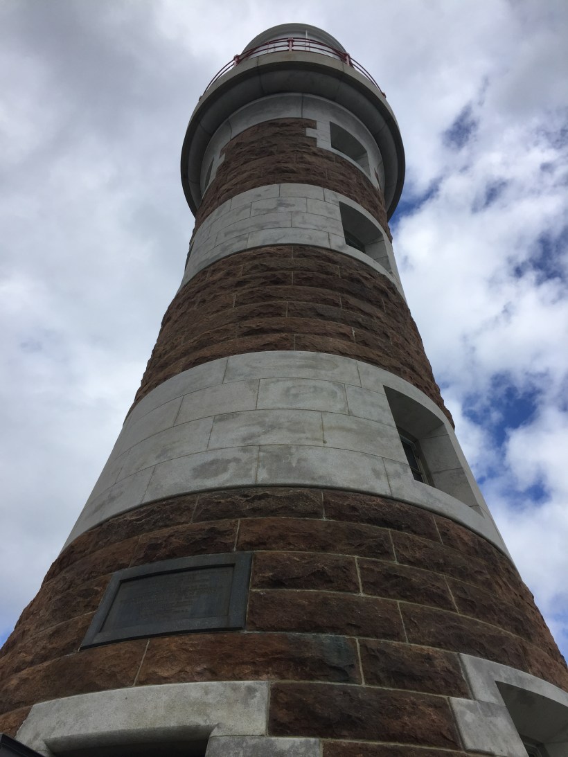
Once the main arm of the pier was complete, work began on the construction of the roundhead for the lighthouse. Henry Wake laid the final stone, embedded in the lighthouse parapet walkway, on 14th July 1903. The Roker Lighthouse was built of alternating red and grey Aberdeen granite. The lighthouse has never been painted and the colouring is natural. It has weathered and dulled over time but must have been vibrant when first constructed. The Grade II listed structure stands 82 feet tall and is equipped with a fog horn and lantern, which is visible some 26 miles out to sea.


The Pier and Lighthouse was heralded as an engineering masterpiece and garnered national attention drawing crowds of people when it was completed.


Work on the south pier began in 1893 and, after construction was disrupted during the First World War, was completed in 1922. It was shortened so as not to restrict access to the river and is smaller than the north pier. The sister lighthouse, which was intended for the New South Pier, was never constructed with a column and fixed light being used.


Roker Pier and Lighthouse have stood guard over the mouth of the River Wear for the last 103 years. They’ve bore witness to many changes over that time. As well as performing it core functions of protecting shipping it has been a tourist attraction and was even used to mount a torpedo battery during World War Two. The concrete casemates are still present to be seen at the end of the pier. It’s fantastic that Sunderland City Council has invested in the restoration of this magnificent structure, which will allow it to be experienced as never before!
I’d like to thank the following sources for the information and images used in this blog.
- Matt Storey Project Co-ordinator for the restoration of Roker Pier and Lighthouse at Sunderland City Council (http://www.rokerpier.co.uk/) for providing the majority of the images in this blog and allowing me to visit the lighthouse;
- Matthew Town and Penny Middleton at Northern Archaeological Associates Limited (http://www.northernarchaeologicalassociates.co.uk/) for allowing me to reference their superb Roker Pier and Lighthouse: Conservation Management and Maintenance Plan;
- Paintings were posted on Facebook by Sunderland Remembered;
- Britain from Above (http://www.britainfromabove.org.uk/);
- Journal of Marine Engineering.